Operating basics and graphic user interface
With the beacon on, the application shares your GPS location with other users of the group using the current Internet connection at a frequency equal to the frequency of updating coordinates. Other users of your group in this case will be able to see your location on the map as a marker. Location can be determined by GPS and (or) base stations. The last location data you have sent will be available to other users of the group for another 12 hours. So other users of the group will be able to see your last location during this time. Group users can always evaluate the relevance (freshness) of your data in the information window of your marker. When a group changes, the location data from the previous group is deleted. For better accuracy, it is recommended to set the "High accuracy" mode (all sources) in the Android system location settings. The current Internet connection used for data transfer can be any (mobile data or WiFi). The frequency of updating the location of the device may vary in the settings of the application. To improve the relevance of the data and the accuracy of your location in time, it is recommended to set the minimum (zero) "Location update interval". In this case, Your location will be transmitted in time close to real (about 1 time per second). The accuracy of the recording route also depends on the frequency of updating the location.
For the beacon to work in the background (when the screen is off), the application needs permission to work in the background in the Android system. So, for normal work in the background, the application must be excluded from the list of applications that save energy. When you first start the application will ask for permission to set this parameter automatically. It is also recommended to turn off applications and services that save battery, because they can forcibly stop applications running in the background, or restrict data transfer.
The marker information window (opened when clicking on a marker) shows the current marker data:
- user name;
- data actuality, i.e. how long ago has a user shared his location;
- speed;
- 📐 azimuth;
- 🗻 altitude;
- 🔋 battery level;
The transparency of the markers of other members of the group is determined by the actuality of the marker data. The older the data, the greater the transparency of the marker.
Controls of the main application window:
 |
your marker (your location). |
|---|---|
 |
marker of another member of the group (location of another member of the group). |
 |
sets the map scale once to display your marker in the center of the screen. |
 |
sets the map scale once to display all markers on the screen. |
 |
opens the navigation drawer menu (left curtain). Also available on the slide from left to right on the left edge of the screen. |
 |
opens a tab with controls for recording and displaying routes. |
 |
opens a tab with controls for points on the map. |
Sequential selection of two markers shows a line between them with an indication of the distance.
Navigation drawer
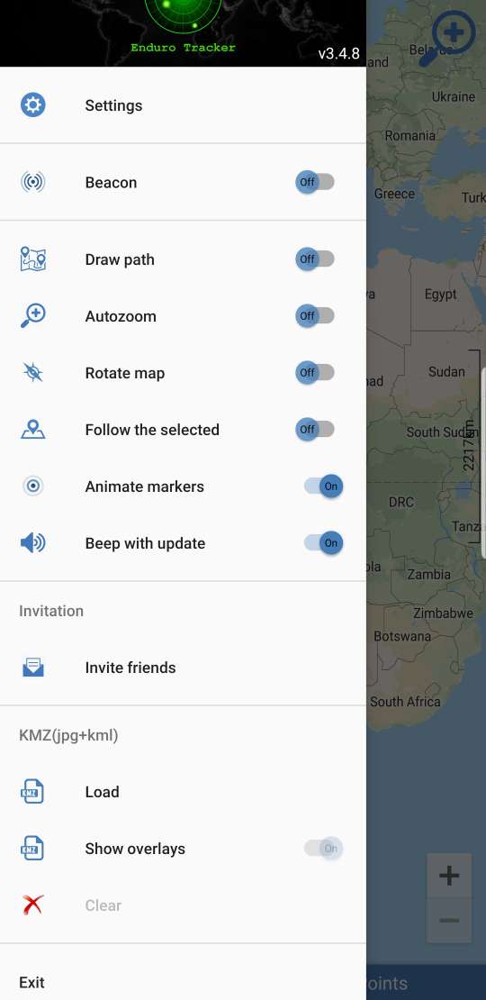 |
Settings allow you to change the current settings of the application (see the "Settings" section). |
|---|---|
|
Beacon When the beacon is on, you are sharing your location with other group members using your current internet connection. When you turn off the beacon, you stop sharing your current location but other members of the group will be able to see your last position within 12 hours. Your update frequency location can be changed in settings. |
|
|
Draw path allows you to display on the map the route traveled since the inclusion of this option. Detailed route on the direct depends on the frequency location updates. When the screen is off, the location of other users of the group is not updated to save data and energy. |
|
|
Autozoom automatically sets the map scale to display all markers on the screen. When performing any actions with the map, the automatic scaling is not performed within the next 5 seconds. |
|
|
Rotate map allows you to automatically rotate the map in the direction of your marker. Disabled if 'Follow the selected' is ON. |
|
|
Follow the selected automatically keeps the selected marker in the center of the screen. Disabled if 'Rotate map' is ON. |
|
|
Animate markers shows animation in the form of divergent circles around the marker when its position is updated. Allows you to visually determine the relevance of marker positions. |
|
|
Beep with update plays a beep when the marker position is updated. The tone of the signal varies depending on the speed of movement of the marker. |
|
|
Invite friends generates a link containing the current group name. You can share this link with any way available on your device. When launching a link on another device, the application will be launched and it will be suggested to change the group name to the name contained in the link. |
|
|
Load
offers to select a KMZ file as a layer for display.
|
Settings
.eng.jpg)
|
Group name allows you to specify a group in which you share your location. Only users with the same group name can see each other. Up to 3 groups are supported simultaneously (separated by commas). Groups: Public Group, Public Group 1, Public Group 2 ... are reserved groups used by the application by default. It is recommended that you use your individual group name to see only your friends using the same group. The text of the group name can be any, but should not exceed 15 characters. Group name is case sensitive. No group registration is required. Quick change of the group is available by clicking the text of the name of the group in the application's main window. |
|---|---|
|
Your name allows you to specify the text of the name displayed on the marker. It is recommended to set a name other than the default name in order to other users of the group could identify the owner of the marker by name. The font size of the name displayed on the marker depends on the number of characters in the name. Marker color for other members On devices of other users, your marker will be displayed in the color set in this setting. Default marker color red. Your marker text color for other members determines what color your name will be displayed on the marker. By default, the text color is determined by its device in a random okay Setting marker colors and text allows you to quickly distinguish your marker among others. Markers type Allows you to select one of the options for displaying the markers of other group members. Map type establishes one of the proposed card style options depending on the goals and preferences. Outdated markers visibility time By default, the application shows only markers, the relevance of which data does not exceed 12 hours. By changing this setting you can Filter markers by relevance. |
|
|
Track data folder allows to change the directory for recorded route files. Automatic track recording start the track recording each time you start the application. Minimal GPS accuracy to record allows you to specify the accuracy at which data will be considered correct and will be added to the route. Data with a precision worse than this will be ignored when recording a route. This setting allows you to avoid adding incorrect positions to the route when the GPS signal disappears or a weak GPS signal (for example, when passing under a bridge, etc.). It is recommended to use the maximum frequency (1 time per second) of the location update (minimum "Location update interval" == 0) for better detail of the recorded route. |
|
.eng.jpg)
|
Location update interval sets the time interval (in sec.) with which the GPS coordinates of the device are requested. It is recommended to set the value to 0 for the highest possible update rate. For most devices, this is about 1 time per second. This will give the most up-to-date information about your location and good route recording accuracy. Increasing the interval will reduce battery and data consumption, but will worsen the accuracy of the route record and the relevance of your data. Measurement units allow you to switch between metric (meters, km, km/h) and Imperial (feet, miles, miles/h) measurement systems. Keep the screen on allows you to keep the screen on while the application is active. Auto start. When this option is enabled, the application will be automatically launched by the operating system upon reboot. |
|
Notifications settings launches the Notifier for Enduro Tracker application. Via this app you can receive notifications about the member of this group has started sharing his location. |
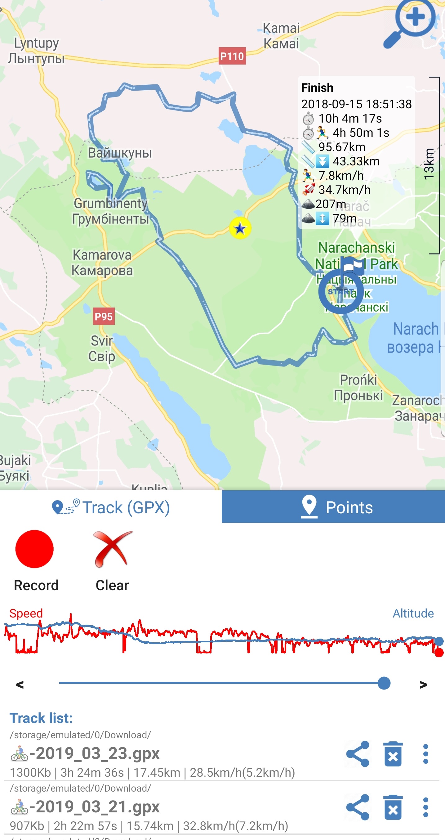
Record and view routes
|
To record a route, use the Record button. After clicking on the "Record" button, all points of location, along with related information, are recorded in the GPX file on the device. The path to the catalog of recorded routes can be changed in the settings. The file name consists of your name (set in the settings) and the date and time of the beginning of the recording. For a good route detail, it is recommended to set the minimum possible "Location update interval" (= 0). A red icon (circle) at the top of the screen signals the recording process. The "Record" button changes to "Finish." The current statistics of the recorded track is visible in the information window of your marker. The Finish button is used to end recording a route. After completion of the recording, the application will offer to download the recorded route. View recorded routes(tracks) When launched, the application scans the device and displays all GPX files on the device as a list (for Android 11+ only Download folder). Each element of the list contains the path to the file directory, the file name and a brief route statistics. Also available are Share , Delete and Rename .
To download and display the route, you must click on one of the list items. The route will be drawn on the map. The map will be automatically scaled to display the entire route.
The beginning and end of the route are marked with appropriate markers. The finish information window displays route statistics. Areas of descent are allocated additionally.
Route statistics include: The speed and height are displayed as red and blue graphs, respectively. Using the slider and buttons below the graphs, you can view individual waypoints. |
|---|
Map points
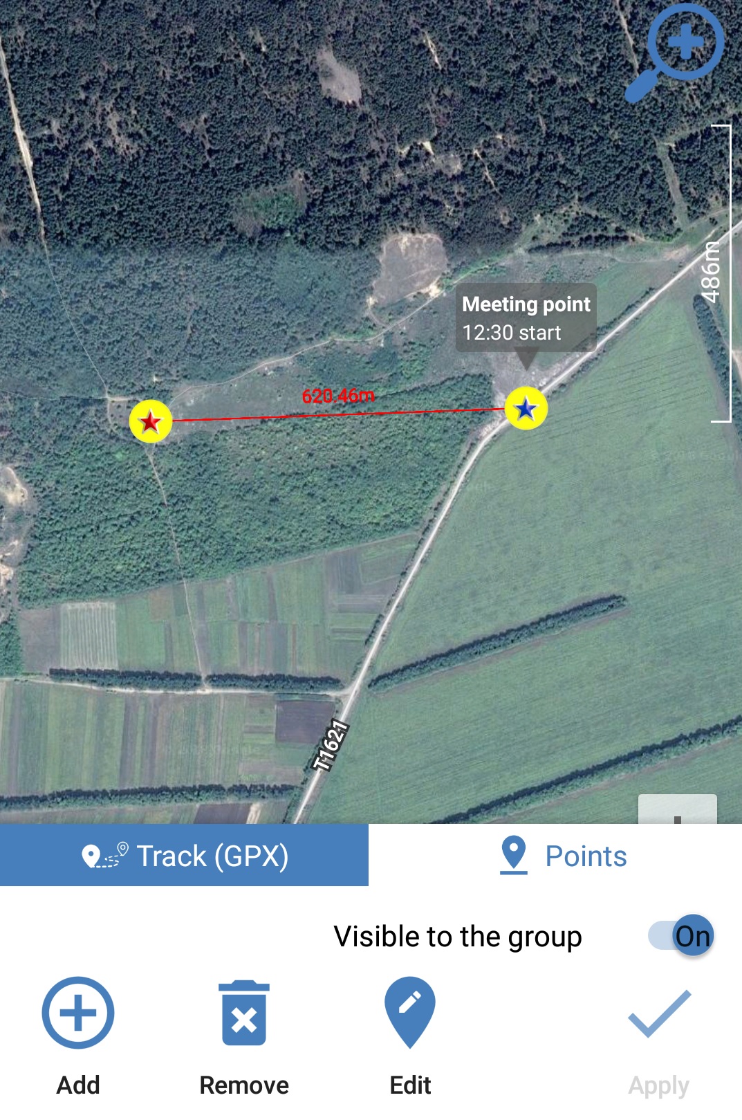
|
The application allows you to mark places on the map by points and make them available to other members of the group. To add a new point, click the "Add" button or with a long click on the map. When you add a new point in a special window, you can change its parameters (name, description and color). After specifying the location of the point (by displacing the map), click "Apply" to fix the point on the map. When the "Visible to group" switch is on, the point will be displayed on the map for all group members within 12 hours. The "Delete" and "Change" buttons are used to delete and edit points, respectively. |
|---|
Troubleshooting
- Track recording or Beacon operation in the background stops after some time (i.e., your marker position stops updating on other devices despite the beacon and the application is running)
The typical reason for this behavior is the power saving of the Android system or third-party power saving programs. Energy saving services can stop the work of applications in the photo.
Please make sure that the energy saving services are turned off, or the application is added to the list of 'not saved battery' programs.
A clear sign of the intervention of energy-saving services in the operation of the application is the correct operation of the beacon with the application active and the screen on.
Please see https://dontkillmyapp.com for details.
- The beacon is enabled but my location is not displayed on devices of other members of the group.
- make sure you have internet connection on your device;
- make sure that the name of the group on your device and on the devices of other participants is completely identical;
- make sure the correct time on your device. The application displays markets with relevance no older than 12 hours, therefore,
If the time on your device differs by more than 12 hours from the time of other devices, your marker will not be displayed on these devices.
Frequently asked questions
- How much energy (battery) does the app consume?
Battery consumption (in %) when the beacon is running in the background (when the screen is off) depends mainly on the "Location Update Interval" and the signal strength of the base stations (for data transmission). When the coordinates are updated once per second, for an average modern device, this consumption may be about 10% per hour.
- Will the application work without an internet connection?
The application uses the current Internet connection to transfer data about your location when the beacon is on, as well as to update the location of other group members on the map.
So, without an Internet connection, you will not be able to share your location and see your friends on the map. If the Internet connection is temporarily lost, the data is cached and transferred when the connection appears.
Internet connection is not necessary to record the route!
- How relevant are the maps?
The application uses Google Maps service to display maps. The relevance of the maps corresponds to the relevance of Google Maps.
Any questions or feedback?
Write to developer on email adress bitssquadpl@gmail.com. We are pleased to answer questions and consider your suggestions.
NEW!
Optimized mode.
The mode is designed to reduce energy and data consumption.
The application automatically increases the 'location update interval' if no group member is watching and the track is not being recorded.
The 'location update interval' returns to the one set in the settings if at least one of the group members is watching your location at the current time.
The function is not available for public groups.
Web app integration to your site
To integrage web app to your site use iframe element with an src=https://endurotracker.web.app/app.html?groupid=yourgroup
Specify the desired group in the 'groupid' parameter.
Used libraries
- OpenStreetMap-Tools for Android https://github.com/osmdroid/osmdroid
- jjoe64/GraphView https://github.com/jjoe64/GraphView